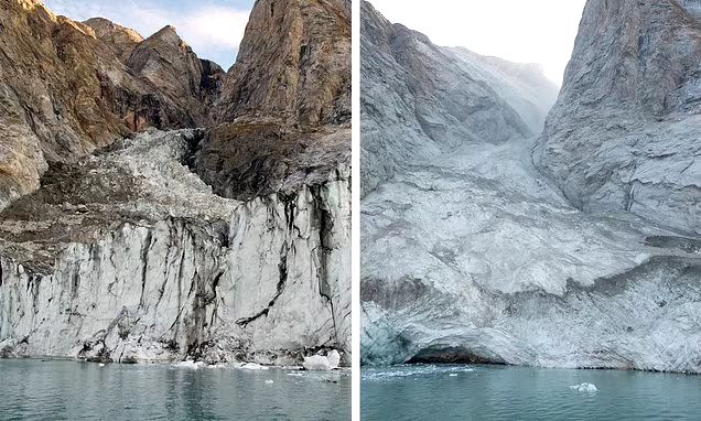
After a mountaintop collapsed into the sea in Greenland, a ‘mega-tsunami’ as tall as a skyscraper shook the Earth for nine straight days, baffling scientists around the world.
No one was injured by the landslide or resulting tsunami, but the 650-foot-tall wave destroyed roughly $200,000 worth of infrastructure at an unoccupied research station on Ella Island.
What’s more, the events occurred near a route that is commonly traveled by cruise ships. Had one been sailing through at this time, it could have led to tragedy.
Until now, no one knew what caused the mysterious seismic activity that began in September 2023 and lasted over a week. It took an international team of scientists to trace it back to the landslide.
‘When we set out on this scientific adventure, everybody was puzzled and no one had the faintest idea what caused this signal,’ said Kristian Svennevig, study lead author and geologist at the Geological Survey of Denmark and Greenland.
Svennevig and her colleagues now believe that climate change set the stage for this landslide by melting a glacier at the base of the mountain and destabilizing enough ice and rock to fill 10,000 Olympic swimming pools.
And as rising global temperatures continue to melt Earth’s polar regions, destructive landslides like this one could become more common.
The research team published their findings today in the journal Science.
When seismic monitoring networks first detected the activity, scientists were perplexed for two reasons.
First, the signal was much more spread out than the typical tight squiggles that an earthquake produces on a seismograph – a device used to record ground shaking.
‘It oscillated with a 92-second-interval between its peaks, too slow for humans to perceive,’ according to a statement from the University of California San Diego, one of the institutions that contributed to the research.
Second, the signal remained strong for nine straight days. Typical seismic events decay much more rapidly – the average earthquake lasts only seconds to minutes.
Scientists around the world quickly began working to get to the bottom of this strange signal.
Discussions online eventually turned up reports of a massive landslide that occurred on a mountain overlooking a remote fjord in East Greenland on September 16 2023.
To determine whether the landslide was connected to the mysterious shaking, a team of researchers led by Svennevig digitally reconstructed the landslide and resulting shakes.
They did this using a combination of seismic recordings from around the world, field measurements, satellite imagery and computer simulations.
The researchers also used supercomputers to simulate the 650-foot-tall mega-tsunami triggered by the 33 million cubic yards of rock and ice that crashed into the fjord.
The waves sloshed back and forth inside the fjord in a phenomenon known as seiche. The researchers concluded that this sloshing is what caused the nine-day stretch of seismic activity that rocked the Earth last year.
‘Ultimately, it took a plethora of geophysical observations and numerical modeling from researchers across many countries to put the puzzle together and get a complete picture of what had occurred,’ said co-author Robert Anthony, a geophysicist with the United States Geological Survey’s Earthquake Hazards program, in a statement.
The findings demonstrate the ‘complex, cascading hazards’ driven by the impact of climate change on Earth’s polar regions, according to the researchers.
‘Climate change is shifting what is typical on Earth, and it can set unusual events into motion,’ said co-author Alice Gabriel, a seismologist at the University of California San Diego, in a statement.
Fortunately, no people were in the area when the enormous landslide and resulting tsunami occurred. But this incident emphasizes the importance of monitoring polar regions as climate change accelerates.
Credit: Daily Mail


Leave a Reply